Explore the world of LIDAR systems: their components, working principle, types, applications, and future prospects in this comprehensive guide.
Understanding LIDAR Systems
LIDAR, an acronym for Light Detection and Ranging, is a sophisticated remote sensing technology that measures the distance to an object or surface by bouncing off light, usually in the form of a pulsed laser, and analyzing the backscattered signal. LIDAR systems have found extensive usage in various fields, including meteorology, geology, archaeology, geography, geophysics, and transportation, among others.
Components of a LIDAR System
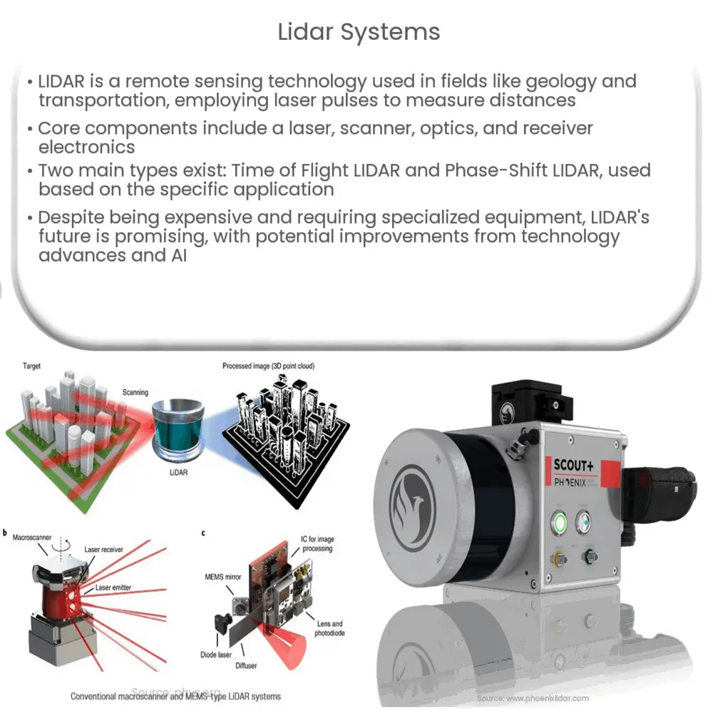
At its core, a LIDAR system comprises three essential components:
- Laser: This is a device that emits light through a process called optical amplification. The intensity and frequency of the light produced by the laser are critical in determining the accuracy of the measurements.
- Scanner and Optics: These components are responsible for directing the emitted laser light towards the object or surface to be measured. They also capture the reflected light.
- Photodetector and Receiver Electronics: Once the light is reflected back, these components detect and record the signal.
Working Principle of LIDAR Systems
The principle of LIDAR is relatively straightforward: it involves the emission of laser pulses towards an object or surface and then capturing the reflection. The time taken for the light to travel back and forth is recorded. Since the speed of light is constant, this time can be used to calculate the distance.
Types of LIDAR
LIDAR systems can be broadly classified into two types based on the method of measuring distance:
- Time of Flight LIDAR: Also known as Pulsed LIDAR, this type of system measures the time taken for the laser beam to travel to the target and back. This is the more commonly used LIDAR system.
- Phase-Shift LIDAR: In this type, the system measures the phase shift in the returning laser light to calculate the distance. These systems are often used in high-speed applications.
Moreover, there are also distinctions based on the platforms used to deploy the system. There are airborne LIDAR systems often used in topographical mapping and terrestrial LIDAR systems used for high-resolution surveying and 3D modelling. The deployment method significantly influences the system’s design and operation.
Applications of LIDAR Systems
LIDAR technology has a broad range of applications in various sectors:
- Geology and Soil Science: By mapping the surface of the Earth, scientists can track changes in terrain and study erosion, landslides, and other geological features.
- Atmospheric Research and Meteorology: LIDAR systems can measure the presence and concentration of different chemicals in the atmosphere, helping researchers study air pollution, weather patterns, and climate change.
- Autonomous Vehicles: Self-driving vehicles use LIDAR to detect and avoid obstacles, providing detailed 3D maps for navigation.
- Archaeology: LIDAR can uncover structures and features hidden under vegetation, aiding in archaeological research and the discovery of historical sites.
The Advantages and Limitations of LIDAR
LIDAR systems come with several benefits. They can gather precise, high-resolution data quickly, making them suitable for large-scale mapping projects. They can also penetrate through certain obstructions like vegetation, allowing for more detailed surveys. Despite the many benefits, LIDAR systems do come with limitations. They are typically more expensive than other remote sensing technologies, and they require specialized equipment and expertise to operate. Additionally, LIDAR can struggle with interpreting certain materials and surfaces, like water and reflective surfaces, which can affect data accuracy.
Future of LIDAR Systems
The future of LIDAR systems looks promising. Technological advances are expected to make these systems more accessible, efficient, and accurate. For example, solid-state LIDARs, which are compact, durable, and inexpensive, may soon replace traditional mechanical LIDARs. Moreover, advancements in machine learning and artificial intelligence could help automate the data processing and interpretation process, leading to faster, more accurate results.
Conclusion
In conclusion, LIDAR technology represents a significant leap in remote sensing capabilities. Despite its limitations, it has become an indispensable tool in a wide range of fields, from geology to transportation. As technology continues to advance, we can expect LIDAR to play an even more prominent role in our understanding of the world around us. Whether it’s mapping the ocean floor or guiding self-driving cars, the possibilities with LIDAR are virtually endless.